


The Jedi Wizard is bringing a somewhat new- but mainly a newly applied use of quantum technology that is usually in practice spanning other industries and sectors, as you can see from this website. But the silver placer mining and the mining industry in general can benefit immensely with radionic ground mapping- The silver mine analysis + service – Lets call it “silver radar” or “Quantum dowsing”. The potential for you to know through draft mapping + plus measurements what’s below ground or in a rock mine will blow your mind.
Having your ground mapped and indexed by the Jedi Wizard will allow you to know whats there, and let you prioritize where you mine first, second, and how deep. If there is a mother lode, you will know it.
The tech to send frequencies into the ground and read back the bounce are not new. Oil and gas has had their own tech for ground penetrating low freq waves for decades so they drill in the right spots and ID gas, oil etc. What does the gold mine industry have? Test hole drill rigs. At a cost of $20K a day. Through trending analysis, you can determine and make judgements about how much you will invest in that ground.
Well now the Jedi Wizard gives the mining industry radionics to look into the ground and get a map made of whats in there. We can create a laundry list of questions when doing underground radionic mapping. ANY questions you want to know! Here is a list a miner could want to know on an acre placer lot before he buys the lot, excavates, brings in equipment, spends capital, or even down to setting up the right riffles to catch a wider array of silver from fine to coarse. The following would be given to a gold miner but the principles apply the same for silver on a case by case basis:

The silver element gives of a frequency, a sort of “tune”. Radionics can measure all of that and get an amplitude number. Within a target zone, we can count how many nuggets there are.. of whatever parameter you state, and get a number or oz / unit. For example, we measure a plot of 10 yards wide x 10 yards high x 10 yards deep, thus a cube of 1000 yards square, in total. From there a map can be depicted of nugget pin pints and an estimated weigh in the silver that exists in that cube. We can scale it up, way up such as a huge lot in the Yukon that is virgin ground, and measure for example a swath of 150 yards, by 90 going down 23 feet. Your list of boolean queries is given, and the JW gives you a map and data points. Now you know what areas to go for first during your short season when the climate clock is a factor. While areas that have lighter density/weighs will get done last or not at all at the end of the season. All this data is extremely valuable to not only save time and money but go for the jackpot zones first, while not wasting precious time and fuel spinning wheels on inferior pay!

The general concept of radionic photography can be read up on if the concept interests you. But this service is done manual, then made in software. Yet nevertheless, the contents of whats behind the mountain or below ground and how much can be mapped. The concept was already done in the 30’s. Today the tech used is far smoother, quicker with just as much or more accurate. But I digress…
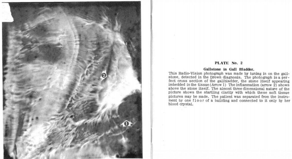

Sample of mapping the body for diseases with radionics. Pioneered by G. De La Warr and Ruth Drown

Mysteries of where and how much are over.
Radionics in gold mining should have been ubiquitous by now… Well, it’s never to late.

Your reports will look similar to this sample. You set the boolean questions as per your needs. Whether actively mining, or pre land purchase etc.
MINING QUANTUM DOWSING SOLUTIONS
REQUEST TO BOOK SILVER MINE ANALYSIS+ SERVICE:
Book a FREE CALL AND FREE DEMO.
"*" indicates required fields
See similar service: Gold mine analysis +
